|
|
Post by MonkeyMan on Sept 4, 2015 12:49:57 GMT -5
|
|
|
|
Post by BBB on Sept 4, 2015 20:52:16 GMT -5
Cool photo. The image has an overlay that makes two of the dudes look like they have tribal art tattoos on there faces  The back of the photo appears to have a newspaper clipping that lists the names of the operators. |
|
|
|
Post by MonkeyMan on Sept 5, 2015 12:54:39 GMT -5
I toured the Pottstown hs A/V dept a few years back with my son's Cub Scout pack. The equipment in that pic might still be sitting on a self in a storage room! The door was open so I took a peek and saw that it was loaded with all sorts of electronic goodies. Eye candy for geeks.  |
|
|
|
Post by cbrown on Sept 8, 2015 9:46:07 GMT -5
An Astatic T-3 head! Very nice!
|
|
|
|
Post by BBB on Sept 9, 2015 17:29:54 GMT -5
An Astatic T-3 head! Very nice! I never saw one of those...cool bullet looking. |
|
|
|
Post by cbrown on Sept 10, 2015 9:13:57 GMT -5
They are a tough (and expensive) find nowadays. The harmonica players try and grab them before any one else.
|
|
|
|
Post by MonkeyMan on Apr 14, 2016 20:20:06 GMT -5
|
|
|
|
Post by BBB on Apr 16, 2016 7:58:21 GMT -5
Where is Chicken Hill?
|
|
|
|
Post by MonkeyMan on Apr 16, 2016 8:54:28 GMT -5
Chicken Hill is an undefined area, roughly between Wilson & Jackson streets to the North, Beech to the South, N. Franklin to the West and Mintzer to the East. If you've ever been to Brunishes you were on top of Chicken Hill. Old maps show it as Washington Hill and it was used as a look-out by the Continental Troops when they were at Camp Pottsgrove, before heading to Germantown and eventually the winter encampment at Valley Forge. Thanks for asking. EDIT: As an aside, if you've never been to Brunishes it's worth a stop for the experience. |
|
Sandbagger
Administrator/The Boss 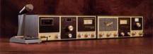
Posts: 6,247 
|
Post by Sandbagger on Apr 16, 2016 20:00:48 GMT -5
Chicken Hill is an undefined area, roughly between Wilson & Jackson streets to the North, Beech to the South, N. Franklin to the West and Mintzer to the East. If you've ever been to Brunishes you were on top of Chicken Hill. Old maps show it as Washington Hill and it was used as a look-out by the Continental Troops when they were at Camp Pottsgrove, before heading to Germantown and eventually the winter encampment at Valley Forge. Thanks for asking. EDIT: As an aside, if you've never been to Brunishes it's worth a stop for the experience. So you're talking about the area where Pottstown High school and the Hill School athletic fields are? |
|
|
|
Post by MonkeyMan on Apr 16, 2016 21:26:25 GMT -5
Chicken Hill is an undefined area, roughly between Wilson & Jackson streets to the North, Beech to the South, N. Franklin to the West and Mintzer to the East. If you've ever been to Brunishes you were on top of Chicken Hill. Old maps show it as Washington Hill and it was used as a look-out by the Continental Troops when they were at Camp Pottsgrove, before heading to Germantown and eventually the winter encampment at Valley Forge. Thanks for asking. EDIT: As an aside, if you've never been to Brunishes it's worth a stop for the experience. So you're talking about the area where Pottstown High school and the Hill School athletic fields are? Basically, right near where Bluebird lived in what I had referred to as a chicken coop. Turns out that wasn't far from the truth.  |
|
|
|
Post by BBB on Apr 18, 2016 9:15:57 GMT -5
Ah, right near Camera Man. I will definitely try them out! Thanks for the tip.
|
|


